Wellington husband and wife team, Aran and Maeve Pudney, create 3D wooden maps of coastlines, mountains, cities and townships. Maeve chats about the technical and emotive process behind these intricate pieces of topographical art.
What gave you and Aran the idea of doing 3D nautical and mountainous maps?
Previously, Aran owned a 3D rapid prototyping business and made several landscape models for architects. He’s always loved maps and it was a natural progression to translate these models in a layered format suitable for laser cutting. The very first Furnace piece he made was for a fundraiser for our local playcentre, and the response was very positive. This set us on the journey to develop the concept further.

Do you and Aran have a particular interest in sailing, fishing, skiing and the outdoors?
We both have always had a love for the sea. The beach has always been my happy place, and going to the beach was always an exciting day out when I was growing up. I grew up in Sligo in the West of Ireland, and it has many beautiful sandy beaches where the Atlantic ocean rolls in. We would go for a walk on the beach, a swim and a picnic in all kinds of weather. Now I have children of my own and we are lucky enough to live close to Lyall Bay beach in Wellington, I am enjoying sharing my love of the sea with them.
Aran’s family has had a bach in Kenepuru Sound in the Marlborough Sounds for almost 50 years, so many of his childhood memories are from down there, in and around the sea, out on the water, or up in the wild and rugged beech forests. The bach is central to many family get togethers over the years, from weddings and birthdays to every Christmas since 1974! It still forms a hub where the extended family congregate, and is starting to form the memories of a third generation now.


How do you capture the topographical information so accurately?
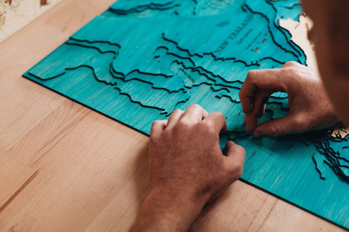
We use the latest bathymetric and topographic data from LINZ and NIWA to create our contour lines, in addition to our highly detailed street maps. We also use marine navigation charts to get our depth information, undersea features and geographic place names. It’s really a mix of the old paper charts, and the latest high definition sonar surveys, brought together to represent these places in a visual and artistic format people can really connect with.
You get a lot of requests for spots around Wellington and New Zealand that are meaningful to people. What is the most far-flung or obscure spot that someone has asked you to recreate?
Our most unusual Furnace piece has been the tiny island of Bornholm, off Sweden. A Swedish client, who lives on the Kapiti coast, wanted something special for his brother’s wedding on Bornholm. We marked the wedding location, as well as the little village everyone was staying in, and engraved a special message on the back.
Another unusual one was for New Belgrade in Serbia, on the Danube River. We were able to find highly detailed street data for this one, which balanced nicely against the simple blue lines of the Danube and Sava rivers.
The most obscure place we’ve done so far in New Zealand was probably Winton. Previously all our maps had variations in ground levels, either above ground or below water level. Winton is quite flat and has a very small river running through it, which we were able to make a feature of. We were pleasantly surprised at how it turned out. It’s a wedding present for someone who is getting married in the new year so we don’t know how it has been received yet.


What has been one of the most difficult areas to recreate and why?
The most time-consuming design so far has definitely been the Marlborough Sounds. The design of intricate waterways, bays and islands takes almost two weeks to complete, but it’s a spot that conjures up those memories of fishing, picnics and days out on the water for many Kiwis.

So there is no limit to what The Furnace can capture?
It’s looking that way! We have a new website with custom ordering system where you can upload the exact image of the area you want. We’re getting more requests for international locations, and have done some of the Pacific Islands – Rarotonga and Fiji – and are working on Australia at the moment. Our latest request is for a rural location in Zimbabwe! What we can do depends on the availability of survey data for the location; some are easier to access than others! We have had a lot of requests for locations in the UK. The waiting time for a custom design is 2-3 months.