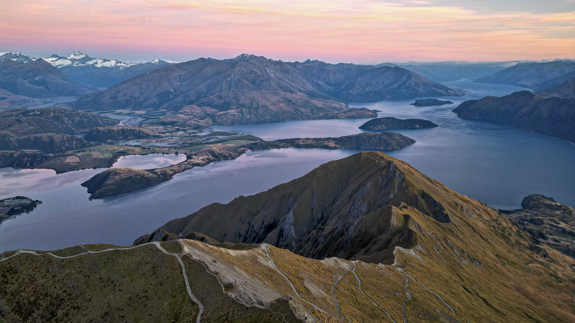
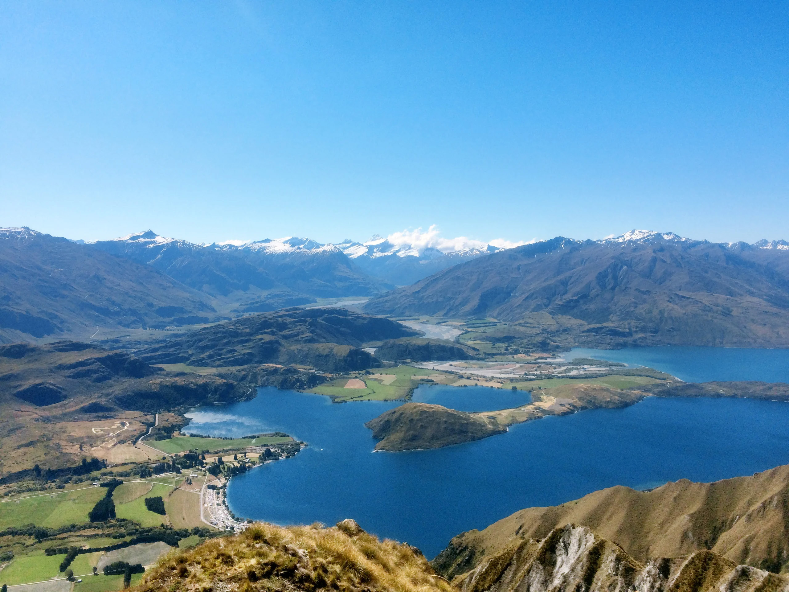
When it comes to stunning scenery, we are spoilt for choice in New Zealand. Central Otago boasts some of our most incredible sights, and looking back on the sunny afternoon that had me standing at the summit of Roy’s Peak, Wanaka, I certainly remember it being breathtaking – in more ways than one. Besides being awestruck by the picturesque landscapes before me, I’d just worked up a pretty mean sweat to get there. But reaching Roy’s Peak – 1578m above sea level – reminded me of three things: how blessed we are in this part of the world, that good things take time, and hard work pays off.
Visiting the Wanaka region is a must-do – it’s a magical and thriving place at any time of the year, well-known for its ski slopes, wine and friendly locals. While there are many walking trails on offer, Roy’s Peak is particularly popular, providing 360-degree panoramic views of Lake Wanaka, the surrounding Southern Alps and Mount Aspiring/Tititea. The peak is named after Scottish outlaw-turned-hero Rob Roy MacGregor, who was known as a kind of Scottish Robin Hood. He explored the area and began farming in the Matukituki Valley in the 1870s. Consistently steep, this is a demanding walk, but one that will reward you with views that look even better than the postcards they feature in.
While recommended for those with moderate to high fitness levels, anyone can walk the trail – you’ll just have to allow yourself more time in order to complete the 16km return track. You don’t have to walk the whole distance to claim an Instagram-worthy snap either, as there are incredible and historic viewpoints from early on, such as the grave site of Wallis Alan Scaife, who owned the nearby Glendhu Station for fifty years, which you can get to approximately 25 minutes after starting your ascent. If you’re looking to go the distance, DOC recommends sparing around five to six hours to complete the walk, which starts at the Roy’s Peak car park, 6km from the Wanaka township on the Mt Aspiring Road. In the summertime the car park is commonly full, so it’s worth considering cycling or walking to the car park.
The track consists of two main sections, the first going through paddocks which consists of mostly grass walking. The second section and the higher you get features gravel and dirt tracks among alpine tussock – which can be slippery if it has rained – so make sure you have tramping shoes or trainers with good grip. The track crosses private land with livestock, so stick to the trail and treat the area with respect.
Another thing to note is be mindful of the weather: come equipped for all conditions, as the area is known for it’s rapidly changing conditions which can see sunshine one minute, and thunderstorms the next. Both heatstroke and hypothermia are real risks during the warmer months, with the track being predominately exposed. Pack plenty of water and warm, windproof clothing before heading off. And one more thing – don’t forget a camera – it’s views like this that you’ll want to capture and frame forever.
Details
Distance: 16km return via the same track
Walk time – five to six hours
Track closed for lambing from 1 October to 10 November.